The Trails Were Here Long Before Europeans Arrived: Indigenous Pathways, Living Heritage and Reconciliation
From ancient travel routes and archaeological discoveries to contemporary Indigenous interpretation, the 2026 Niagara Geopark Trail Network Summit explored how the pathways that connected Niagara for thousands of years continue to shape the region today.
When we walk a trail in Niagara today, we may think about the scenery, the distance or the destination.
But many of the routes through this landscape have histories stretching back thousands of years.
Long before modern roads, recreational trails or municipal boundaries, Indigenous Peoples travelled across Niagara along extensive networks connecting communities, waterways, gathering places and trading routes.
At the November 5 Niagara Geopark Trail Network Summit, two presentations explored these connections from complementary perspectives: the archaeological evidence of Indigenous trail systems and the importance of recognizing these pathways as living heritage.
Together, they reinforced an important message: Niagara’s Indigenous trails are not simply part of our past. They continue to shape how we understand the land and our relationships with it today.
Long Stretches of Country to Traverse
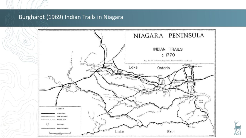 In his presentation, Long Stretches of Country to Traverse: Indigenous Trail Systems, Martin S. Cooper, Senior Associate with Archaeological Services Inc. (ASI), explored how Niagara’s geography influenced Indigenous travel, settlement and trade.
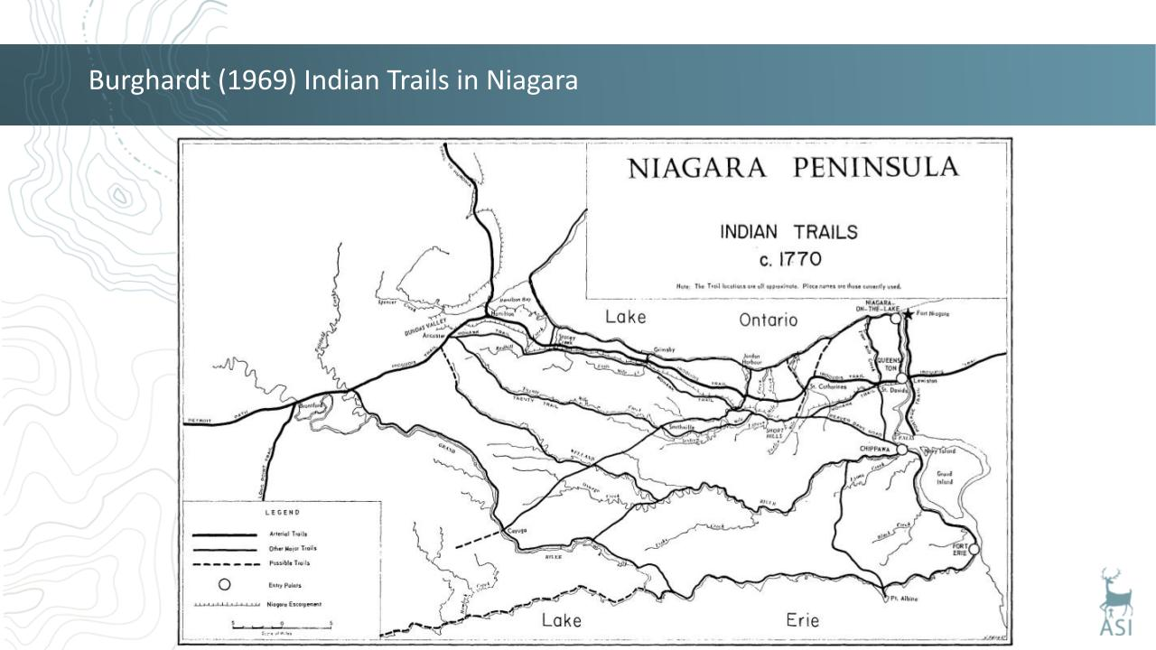
Two major east-west routes were particularly important.
The Iroquois Trail followed the ancient shoreline of Glacial Lake Iroquois, while the Mohawk Trail extended along the brow of the Niagara Escarpment.
These routes connected Niagara to extensive travel networks reaching the Grand River, Thames River, Detroit and the Ohio Valley.
Cooper emphasized the scale of travel and exchange that existed long before European arrival.
“People often underestimate the amount of travel that was done even before the Europeans arrived.”
He described how Iroquoian-speaking peoples travelled vast distances, maintaining connections across northeastern North America and beyond.
Niagara was not an isolated region. Its trail systems formed part of a much larger network of movement, trade and relationships.
What Archaeology Reveals About the Trails
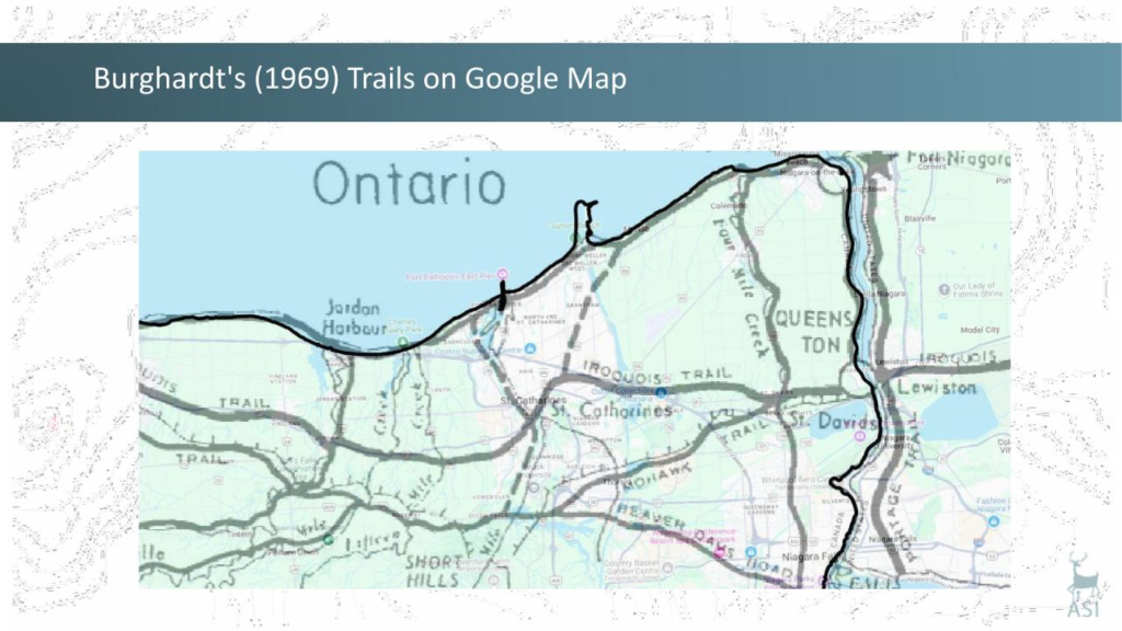 Cooper’s archaeological research demonstrated just how closely Indigenous settlement patterns were connected to these routes.
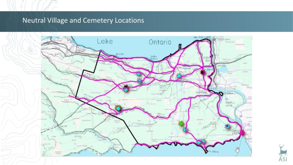
“All of the 24 known Neutral sites located on the northern part of the Niagara Peninsula are situated on one of these two major east-west trails.”
Rather than being scattered randomly across the landscape, Neutral villages and associated cemeteries followed recognizable patterns along the Iroquois and Mohawk Trails.
His research in southeastern Niagara also revealed that village locations were influenced by geological features, including post-glacial beaches, sandbars and the Onondaga Escarpment.
These landforms provided well-drained soils suitable for growing maize in areas otherwise characterized by poorly drained land.
The landscape also offered important natural resources.
Along Lake Erie, shoreline locations provided access to spring walleye fisheries and high-quality Onondaga chert, a stone used for making tools and traded across northeastern North America.
These findings demonstrate how closely Indigenous communities understood and worked with Niagara’s geological landscape.
The trails followed the land, and the land helped shape where people travelled, traded and established communities.
Protecting the Archaeological Record
 Cooper also discussed how archaeological research informs contemporary land-use planning.
In 2020, Archaeological Services Inc. undertook an Archaeological Management Plan for Niagara Region, using known archaeological sites and geographic information to identify areas where additional archaeological resources may exist.
The plan helps municipal planners determine where archaeological assessments may be required before new housing, infrastructure or other development proceeds.
As Cooper explained:
“An archaeological management plan represents a comprehensive approach to the conservation of archaeological resources.”
This work is an important reminder that Niagara’s Indigenous heritage is not limited to the places already documented.
There are still histories and archaeological resources within the landscape that require care and protection.
Indigenous Peoples Have Witnessed Niagara’s Geological Evolution
Tim Johnson of the Niagara Academy for Indigenous Relations connected this archaeological history with Niagara’s geological story.
He discussed evidence of Indigenous presence in the broader region dating back approximately 13,000 years, around the period when Niagara Falls first emerged following the last ice age.
“That whole time period during which the Falls kind of retreated and eroded back through the gorge, Indigenous peoples have been in the area and have been witnessing the evolution of Niagara Falls since its inception.”
It’s a remarkable perspective.
The geological forces that shaped Niagara and the human histories connected to the landscape are not separate stories. They have unfolded together over thousands of years.
Living Pathways, Not Historical Artifacts
 One of the strongest messages from Johnson’s presentation was the importance of recognizing Indigenous trails as living heritage.
“We treat these pathways as living pathways rather than historical artifacts.”
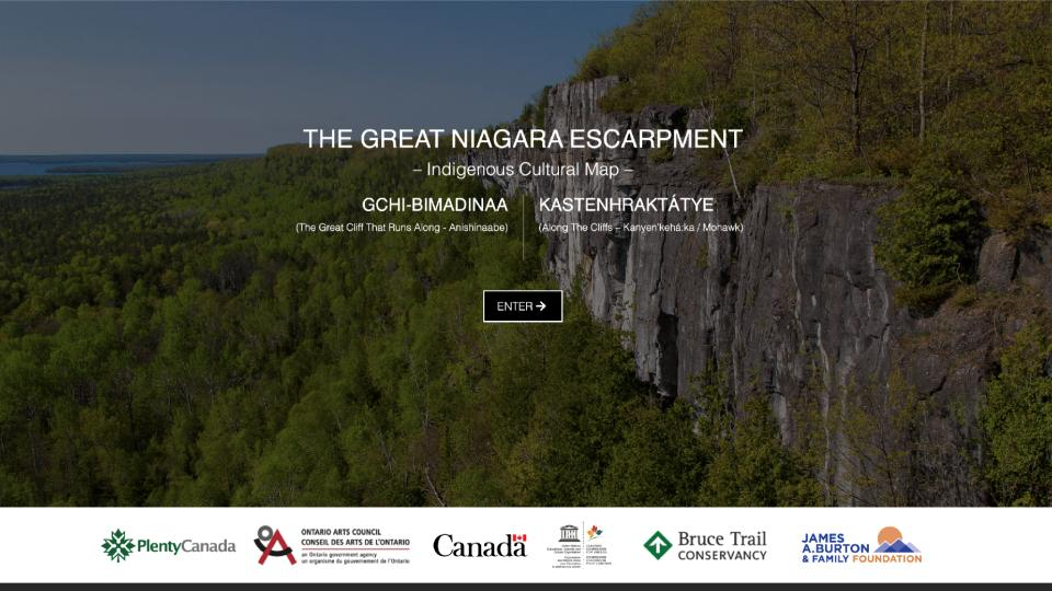
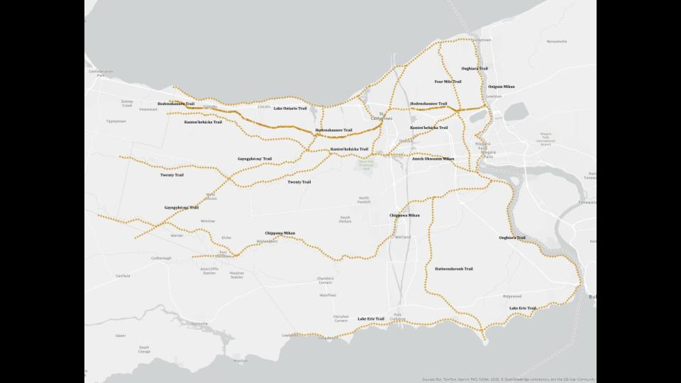
Through the Great Niagara Escarpment Indigenous Cultural Map, the Niagara Academy for Indigenous Relations has worked to reconnect Indigenous voices, place names and cultural histories with locations across the landscape.
The digital mapping platform allows people to explore Indigenous trail systems and learn about culturally significant places.
Importantly, some sensitive locations are represented without precise GPS coordinates to help protect archaeological and cultural resources.
Johnson explained that the work is about more than documenting historical routes.
“Presenting them through these new maps reframes them as living heritage, encouraging engagement with Indigenous peoples and continuity, rather than a past-only narrative.”
Ten Indigenous Trail Signs Across Niagara
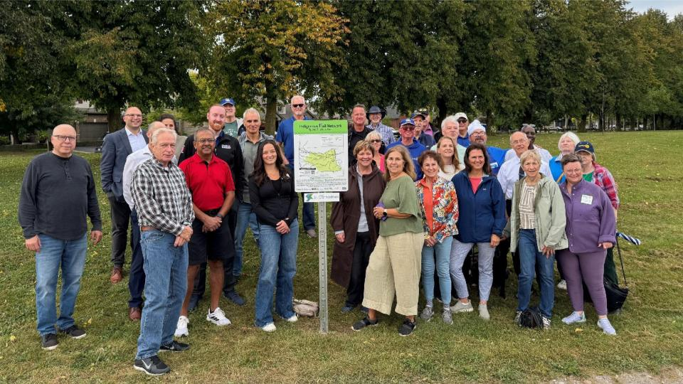 Niagara Geopark is helping bring these stories into the landscape through the installation of 10 Indigenous Trails interpretive signs across the Niagara region.
Developed in collaboration with Indigenous partners, the signs connect locations along the trail network with Indigenous histories, knowledge and the significance of these pathways.
The first sign was unveiled at Brown Homestead in June 2026, marking an important milestone in the initiative.
Each sign provides an opportunity for residents and visitors to discover the deeper stories connected to the places they explore.
Together with Indigenous cultural mapping and the developing Niagara Geopark Trail Network, the signs will help make these histories more accessible while encouraging respectful learning and exploration.
The goal is not simply to identify where trails once existed, but to recognize the continuing presence of Indigenous Peoples and the relationships between the land, its history and its communities.
Reconciliation Through Place-Based Projects
 Johnson highlighted several examples of Indigenous-led and collaborative projects that are bringing these histories into public spaces.
These include the Landscape of Nations Memorial at Queenston Heights, the First Nations Peace Monument in Thorold, Indigenous public art in downtown St. Catharines and Indigenous heritage interpretation in Jordan.
Each project reflects the history and significance of its particular location.
“We really look at that specific location — what’s the history? What’s the story of that location?”
These projects create opportunities for education, reflection and engagement while recognizing Indigenous contributions, knowledge and contemporary cultural expression.
They also demonstrate how reconciliation can be advanced through collaboration.
Johnson offered a practical perspective on building these relationships:
“Get together and then figure out what you can do together.”
He emphasized that working toward shared goals helps build relationships between Indigenous communities, municipalities, conservation organizations and other partners.
Over time, those relationships become an important part of the work itself.
Connecting Language, Ecology and Indigenous Knowledge
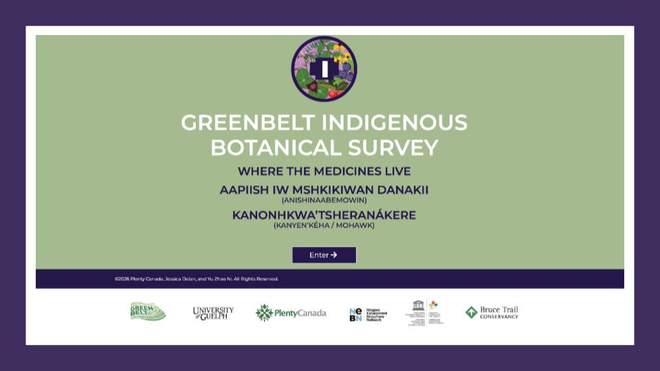 Another important part of Johnson’s presentation explored the connections between Indigenous knowledge and the natural environment.
Through the Greenbelt Indigenous Botanical Survey, Indigenous knowledge holders and scientists studied 23 locations associated with historic Indigenous trails and settlements.
The project documented plant species while incorporating Indigenous-language names alongside scientific and common names.
Johnson emphasized the importance of language revitalization:
“Indigenous languages themselves are like huge repositories of knowledge.”
The project demonstrates how Indigenous knowledge, ecology, language and geological landscapes are deeply interconnected.
It also illustrates how trails can become opportunities for learning that extend far beyond recreation.
Walking Forward Together
For Niagara Geopark, connecting Indigenous trails with contemporary interpretation is an important part of building a more meaningful regional trail network.
The 10 interpretive signs, Indigenous cultural mapping and collaborative educational initiatives are helping people discover histories and relationships that may not be immediately visible in the landscape.
Cooper’s archaeological research helps us understand where these routes existed, why they developed and how Indigenous communities interacted with Niagara’s geography.
Johnson’s work reminds us that these pathways remain part of a living cultural landscape and that their interpretation must recognize Indigenous voices, knowledge and leadership.
Together, their presentations demonstrated why understanding Indigenous trails is essential to understanding Niagara itself.
As Johnson described it, this work supports “place-based reconciliation” — creating opportunities to learn, reflect and build relationships through meaningful connections to the land.
The trails were here long before us. By listening, learning and working together, we can help ensure their stories remain part of Niagara’s living heritage.
The Niagara Trail Summit Blog Series is supported by the Greenbelt Foundation.